
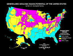
 The purpose of the Radon map is to assist National, State, and local organizations to target their resources and to implement radon-resistant building codes. This map is not intended to be used to determine if a home in a given zone should be tested for radon. Homes with elevated levels of radon have been found in all three zones. All homes should be tested regardless of geographic location.
The Map was developed using five factors to determine radon potential:
1) indoor radon measurements;
2) geology;
3) aerial radioactivity;
4) soil permeability;
and 5) foundation type.
Radon potential assessment is based on geologic provinces. Radon Index Matrix is the quantitative assessment of radon potential. Confidence Index Matrix shows the quantity and quality of the data used to assess radon potential. Geologic Provinces were adapted to county boundaries for the Map of Radon Zones.
Additional Radon related articles:
Radon, What is it? Risks? Basic Information
Radon, and Granite Counter Tops
Radon Testing – New or Current Home
Cliff Daniels
Active Properties
720 434 1418
Boulder Colorado


Pretty section of content. I just stumbled
upon your blog and in accession capital to assert that I acquire actually enjoyed
account your blog posts. Any way I’ll be subscribing to your augment and even I achievement you access consistently rapidly.
my web site: port authority stain
Hey very nice blog!
Feel free to visit my homepage :: d427 camcorder battery batteries